GIS-based multi‐criteria analysis for sustainable urban green spaces planning in emerging towns of Ethiopia: the case of Sululta town
Urban green spaces are important components, contributing in different ways to the quality of human well-being. In the planning and management of urban centres, attention to the appropriate site selection of urban green spaces with regard to the importance that these spaces have from the perspectives of ecology, socioeconomic, mentality, etc., is an inevitable requirement. In present decades, land suitability mapping methods and GIS have been used to support urban green space planners in developed countries; however, its application and practices are limited in developing countries, like Ethiopia. Therefore, the aim of this study has to select potential sites for green spaces in Sululta town that assist an effective planning process of green areas in a sustainable way.
Methods
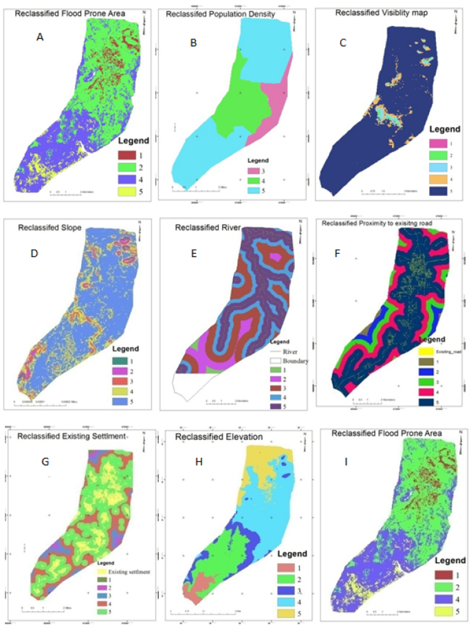
In this study, GIS-based Multi-criteria analysis (MCA) has been adopted to select suitable sites for urban green spaces. Existing land use, proximity to settlement, road and water body, population density, land ownership, topography, and scenic attractiveness were recognized as the key factor affecting urban green land suitability.
Results
The results showed that 13.6%, 34%, 28%, and 18.9% of the study area are highly suitable, suitable, moderately suitable, and poorly suitable, respectively, for urban green spaces development. Furthermore, out of the total area of the study town 5.5% of the landmass is not suitable for urban green spaces development.
Conclusions
Therefore, the application of GIS-based MCA has provided an effective methodology to solve a complex decisional problem in urban green spaces site selection in the study town and urban planning all over the country.
Introduction
With more than 50 % of the global population now living in urban areas, the world has experienced unprecedented urban growth in recent decades (Wu 2014). The global urban population is projected to be 6.3 billion by 2050, almost double the global population of 3.5 billion urban dwellers in 2010 (SCBD 2012). This rapid urbanization has posed greater pressure on natural resources and the environment (Rees and Wackernagel 1996; Shi 2002) and the amount of land exploited for infrastructure development and buildings has increased at the expense of urban green spaces (Sandstrom 2002).
Urban green spaces are of crucial importance, especially in an urbanized world, as they are the key providers of ecosystem services and improve the quality of life of urban residents. For instance, by increasing water infiltration, it promotes the regulation of ecosystem services (Haase and Nuissl 2007; Pauleit and Duhme 2000) and has positive impacts on microclimate regulation (Gill et al. 2000; Hamada and Ohta 2010). It also provides benefits to city residents, such as exercise, socialization, interaction with nature and connection with places of rich cultural heritage (Crompton 2005; Cho et al. 2006; Sarev 2011). It is important to understand in this sense that green spaces are main components of urban environments (Tratalos et al. 2007) not only for their recreation but also for social contributions (Jones et al. 2013), health (Kimberlee et al. 2011) and environmental outcomes (Patel et al. 2009).
Despite the numerous aforementioned benefits, urban green spaces are unable to provide urban dwellers with the desirable facilities due to increased urbanization and unplanned urban growth (Wright and Nebel 2002), lack of proper site selection and planning and lack of attention to population thresholds (Ahmadi et al. 2016). As a result, both quality and quantity of urban green spaces are adversely affected and do not deliver what urban centres demand from urban green spaces as a living organism (Crompton 2001). Therefore, by taking into consideration environmental and social-economic factors, well planned, and well-designed green spaces within the reach of the community are mandatory in order to maximize the value that green spaces bring to urban residents and their environment in a sustainable way (Giles-Corti et al. 2005).
Land suitability analysis is vital in urban green spaces planning as it gives room for choosing the most suitable site from among various alternatives (Sahabo and Mohammed 2016). For suitable site selection, the multi-criteria analysis (MCA) approach that is integrated with the Geographical Information System (GIS) has been increasingly used (Uy and Nakagoshi 2008; Van Berkel et al. 2014; Ustaoglu, and Aydınoglu 2020). In order to determine different land problems considering the alternatives, MCA focuses on various parameters such as biophysical, socio-economic and policy-related factors in decision-making processes (Pramanik, 2016).
The MCA methods have been widely applied in both developed and developing countries to select agricultural sites, industrial sites, residential areas, landfill sites, wind farms, disaster area, health centres, and education centres (Rikalovic et al. 2014; Rahmati et al. 2016; Marsh et al. 2016; Demesouka et al. 2016; Vasileiou et al. 2017). However, the MCA methodology has not commonly used in developing countries such as Ethiopia to select suitable site for urban green spaces development and using MCA in urban planning, as decision-making tools are not practiced.
In parts of Europe, North America and Asia, MCA approach that is integrated with the GIS to identify suitable site for urban green spaces has been receiving more attention and it is considered as one of the essential tools for urban green spaces planning (Nowak et al. 2003; Ustaoglu and Aydinoglu 2020). In order to specifically analyse the characteristics of green areas and possible sites suitable for green spaces in either the European or overseas context, numerous studies were conducted (Kienast et al. 2012; La Rosa and Privitera 2013; Chandio et al. 2014; Morckel 2017; Merry et al. 2018; Ustaoglu and Aydınoglu 2020). However, in developing countries, while some green spaces studies have been performed, the available studies have concentrated largely on the evaluation of urban green spaces with less emphasis on the study of the suitability analysis for green spaces site selection. For instances, the studies in sub-Saharan African countries are primarily related to street trees’ abundance and composition (Kuruneri-Chitepo and Shackleton 2011), green space degradation (Mensah 2014), green space extent (McConnachie et al. 2008; McConnachie and Shackleton 2010) and planning aspects (Cilliers 2009; Fohlmeister et al. 2015).
This situation also occurs in the case of Ethiopia, which is one of the fastest growing countries in sub-Saharan Africa (Lamson-Hall et al. 2018), and studies have focused on the impacts of urban growth on green space (Abebe and Megento 2016; Gashu and Gebre-Egziabher 2018; Abo El Wafa et al. 2018), climate change adaptation (Lindley et al. 2015), the development of functional green infrastructure and ecosystem service (Woldegerima et al. 2017), planning aspect (Girma et al. 2019), green spaces depletion (Girma et al., 2019a) and utilization pattern (Yeshewazerf 2017; Molla et al. 2017; Girma et al. 2019b). However, the topic of suitability analysis for green space in the urban environment by using methods such as GIS-based Multi-criteria analysis has not discussed in these studies. This study therefore aimed to fill the existing research gap by applying GIS-based Multi-criteria analysis method to identify suitable sites for urban green space development in Sululta town.
Materials and methods
Description of the study area
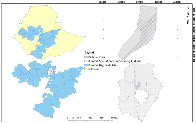
Sululta town is located in Sululta district of the previous North Shewa administrative zone of Oromia region, currently under Oromia special zone surrounding Finfinne. It is situated very close to the district capital town Chancho and Addis Ababa, which are far about 15 and 23 km in the north and south direction, respectively. Astronomically, the study area is located between 9° 30′ 00″ N to 9° 12′ 15″ N latitude and 38° 42′ 0″ E to 38° 46′ 45″ E longitude. The administrative area of the town is about 4471 hectares. Sululta has the same general climatologically characteristics as that of Addis Ababa. Globally it is a part of tropical humid climatic region, which is characterized by warm temperature and high rainfall. The soils of the zone are basically derived from mesozoic sedimentary and volcanic rocks. The major soil types of Suluta area are Chromic Luvisols (Fig. 1).
Methods
Urban green spaces have continuously played a significant role in enhancing the quality of life of urban inhabitants and in supporting urban metabolism. However, urban green spaces have experienced a physical and social decline, while its heterogeneity and richness is often neglected and its contribution to the well-being of a community ignored within current urban planning instruments in Sululta town (Girma et al. 2019; Girma et al. 2019a). Under this circumstance, GIS-based multi-criteria land suitability analysis is becoming critical in determining the land resource that is suitable for urban green spaces (Cetin 2015). Continued development and refinement of suitability analysis, particularly with GIS technology, can enable urban planners to create a suitable urban green spaces system in the urban environment (Manlum 2003).
Several literatures have stated that MCA components are used in only a few GIS programs (e.g. IDRISI and ILWIS) to select appropriate places for different functions (Lesslie et al. 2008; Chen et al. 2001; Ozturk and Batuk 2011). MCA has not yet been implemented in the standard functions, according to the literatures, while ArcGIS is one of the most popular GIS applications. In this study, MCA has incorporated ArcGIS 10.2 as a method to select an appropriate location for the development of urban green space.
Therefore, this study proposed the application of GIS-based multi-criteria suitability analysis using analytical hierarchy process (AHP) to support the decision-making process on selecting an appropriate site for development urban green spaces. This approach will be used as a basis for the town’s administration and the planning authority to identify an appropriate and potential site for providing suitable, sufficient and accessible urban green spaces to the urban dwellers. Moreover, it will be used as a benchmark to guide the sustainable land use decision in the study area.
In this study, to select a suitable site for urban green spaces using GIS-based multi-criteria analysis the following five main steps were used:
- Spatial and non-spatial data collection
- Determination and rating of criteria and sub-criterion
- Criteria standardization and factor map generation
- Determination of weighting for factors and
- Weighted overlay analysis.
Spatial and non‐spatial data collection
The primary data from the field survey were collected through interviews undertaken with different experts in the related field of study for identifying factors that are important for urban green spaces site selection. Various spatial data were also obtained from different secondary sources (Table 1). The data were analysed in ArcGIS 10.2 and ERDAS Imagine 2010 for further analysis and mapping purposes.
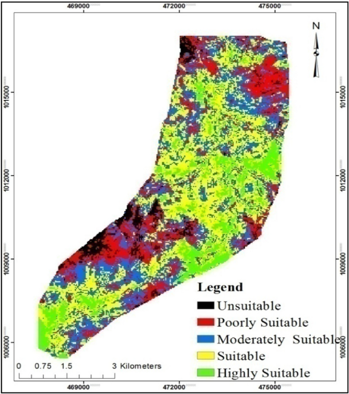
According to the overall suitability map, southern, central and south eastern part of the study area is more adequate for urban green space such as playground, sport field, parks and the like development purposes. It is because the lands mass in this area are fall in suitable and highly suitable classes.
Based on Table 6, out of the total area of the Sululta, town, about 13.6 % (610.7 ha) area fall under the highly suitable category. The suitable area covers an area of 34 % (1523.9 ha) of Sululta town. The area which is shaded by blue colour covers 28 % (1276.6 ha) of Sululta town representing the moderately suitable class. Moreover, based on the Table 6, out of the total area 18.9 % (813 ha) of Sululta towns have been covered by poorly suitable class. Out of the total area 5.5 % of Sululta towns land mass is not suitable for urban green spaces.
Table 6 Area cover of classified land suitability map for Sululta town
The final suitability maps show a series of spaces following a pattern and connectivity. These can be adapted to form the urban green spaces system, complete with corridors and hubs within the study area. This can increase opportunities for residents and biodiversity to enjoy the nature and benefits of urban green spaces. Moreover, as the maps show the town have a high potential for developing the urban green spaces such as playground, sport field, parks and the like as more than half of the town’s lands mass are suitable. Therefore, the planning authority and the towns’ administration can take this approach as a benchmark to provide suitable, accessible, interconnected and sufficient urban green spaces in town under study.
Literature shows that many studies have used multi-criteria analysis based on GIS for land use planning in different countries. Ustaoglu and Aydinoglu (2020), for example, performed a site suitability study for the development of green space in the Pendik district of Turkey. Similar to this study, they considered geophysical factors, accessibility, blue and green amenities, settlement centres and land use/cover as the key factors affecting urban green land suitability and they also concluded that undertaking suitability analysis for green space through GIS based multi criteria analysis is mandatory for optimising land use planning and decision support. Giordano and Riedel (2008) conducted land suitability assessment of greenways in the city of Rio Claro, Brazil. They combined the AHP method with GIS for the analysis of land suitability, similar to this study. Uy and Nakagoshi (2008) used the ecological threshold factor approach and GIS in Hanoi, Vietnam, for land suitability study for green areas. Their research considered the concepts of landscape-ecology in the organisation of urban green spaces. Chandio et al. (2011) used GIS-integrated AHP strategy to evaluate factors such as land availability, land price/value, accessibility and socio-economic factors for the development of public parks in Larkana City, Pakistan. Similar to this study, Abebe and Megento (2017) also considered land use/cover, density, road network and river as the main factor undertake to site suitability analysis of urban green space development for the city of Addis Ababa.
In general, the factors used in this study to select suitable site for urban green spaces such as parks, play grounds and sport filed development is compliant with different studies undertaken in different part of the world. Moreover, similar to studies conducted by Giordano and Riedel (2008), Uy and Nakagoshi (2008), Chandio et al. (2011), Abebe and Megento (2017) and Ustaoglu and Aydinoglu (2020) the methodology applied in this study provide a base for future studies focusing on land suitability assessments. GIS-based multi criteria analysis suitability assessment technique can be utilised to produce land suitability maps regarding other land uses such as industrial, residential, landfill, urban land, water management and forest development. Moreover, the methodologies are complementary with the other green land assessment methods, such as landscape metrics analysis, landscape connectivity analysis, accessibility and network analysis and therefore can be used in green spaces planning to specify and quantify the suitable sites in line with the other approaches.
Conclusions
In this study, GIS-based multi-criteria analysis has been used to support the site selection process for the development of urban green spaces. The study results are very significant in evaluating the feasibility of the use of GIS-based multi-criteria analysis for the development of urban green space. Since, by using appropriate analytical methods, the evaluation of urban green space is necessary to recognize their potential and to better select the most suitable land uses to improve their integrity and maintain the benefits obtained from them.
In the present study, the sub-criteria for site suitability for urban green spaces in order of importance were area with high population density (22 %), Proximity to settlement area (21 %), Slop (13 %), Proximity to the road (10 %), elevation (5.9 %), vegetation cover (4.8 %), Proximity to water sources, visibility and existing land (3.2 %) and flood prone area (4 %). The GIS-based multi-criteria analysis performed in this study found that, in the current situation, the larger land mass (47 %) of the town is suitable for developing urban green spaces. The town, therefore, has great potential to develop adequate urban green spaces.
GIS technologies can play a crucial role in urban green space planning, as shown in this study, and AHP has been shown to be a flexible and realistic tool for selecting areas for urban green spaces in the study area. This can be attributed to participation of experts in the determination of the criteria and sub criteria using AHP. Furthermore, GIS may be used to support spatial decision-making, as it has excellent spatial problem solving capabilities. Therefore, this study can provide a framework for the planning process using GIS and AHP for Ethiopian County planning and the results can be useful in the planning of urban green space and future land use planning in study town.
Finally, future research should focus on assessing the suitable site selection for each urban green spaces component such as park, playground, sport field, and the like, independently. In this study, the same criteria and sub criteria were considered to select suitable site for all components of urban green space. Therefore, considering criteria and sub criteria for each component separately are necessary in order to provide a complete understanding of urban green space suitability analysis.
Availability of data and materials
All data generated or analysed during this study are included in this published article.
References
- Abebe MT, Megento TL (2016) The city of Addis Ababa from ‘Forest city’ to ‘Urban Heat Island’ Assessment of Urban Green Space Dynamics. Journal of Urban Environmental Engineering 10(2):254–262 ArticleGoogle Scholar
- Abebe MT, Megento TL (2017) Urban green space development using GIS-based multicriteria analysis in Addis Ababa metropolis. Appl Geomat 9(4):247–261 ArticleGoogle Scholar
- Abo-El-Wafa H, Yeshitela K, Pauleit S (2018) The use of urban spatial scenario design model as a strategic planning tool for Addis Ababa. Landsc Urban Plan 180:308–318 ArticleGoogle Scholar
- Ahmed IC, Matori A, Umar DL, Sabri S (2011) GIS-based Land Suitability Analysis Using AHP for Public Parks Planning in Larkana City. Modern Applied Science 5(4):178–184 Google Scholar
- Ahmadi N, Golestani MA, Bayzidan M (2016) The current status of urban parks and green spaces in Tehran, Iran. In: Proceedings of the VI international conference on landscape and Urban Horticulture 1189
- Bagheri M, Sulaiman WNA, Vagferi N (2013) Application of geographic information system technique and analytical hierarchy process model for land-use suitability analysis on coastal area. J Coast Conserv 17:1–10 ArticleGoogle Scholar
- Bunruamkaew K, Yuji M (2011) Site Suitability Evaluation for Ecotourism Using GIS & AHP: A Case Study of Surat Thani Province. Thailand. Procedia Social Behavioral Sciences 21:269–278. https://doi.org/10.1016/j.sbspro.2011.07.024ArticleGoogle Scholar
- Chandio IA, Matori AN, Lawal DU, Sabri S (2011) GIS-based land suitability analysis using AHP for public parks planning in Larkana City. Modern applied science 5(4):177 ArticleGoogle Scholar
- Chandio IA, Matori AN, Yusof K, Talpur MAH, Aminu M (2014) GIS-based land suitability analysis of sustainable hillside development. Procedia Eng 77:87–94 ArticleGoogle Scholar
- Chen K, Blong R, Jacobson C (2001) MCE-RISK: integrating multicriteria evaluation and GIS for risk decision-making in natural hazards. Environ Model Softw 16(4):387–397 ArticleGoogle Scholar
- Cho SH, Bowker JM, Park WM (2006) Measuring the contribution of water and green space amenities to housing values: An application and comparison of spatially weighted hedonic models. J Agric Resour Econ 1:485–507 Google Scholar
- Cilliers J (2009) Future direction in urban planning and space usage compensating urban green spaces. Interdis Themes J 1(1):1–10 Google Scholar
- Crompton JL (2001) Financing and acquiring park and recreational resources. Human Kinetics, Champaign Google Scholar
- Crompton JL (2005) The impact of parks on property values: empirical evidence from the past two decades in the United States. Managing Leisure 10(4):203–218 ArticleGoogle Scholar
- Dagistanli C, Turan ID, Dengiz O (2018) Evaluation of the suitability of sites for outdoor recreation using a multi-criteria assessment model. Arab J Geosci 11(17):492 ArticleGoogle Scholar
- Demesouka OE, Vavatsikos AP, Anagnostopoulos KP (2016) Using MACBETH multicriteria technique for GIS-based landfill suitability analysis. J Environ Eng 142:04016042. https://doi.org/10.1061/(ASCE)EE.1943-7870.0001109ArticleCASGoogle Scholar
- Dong J, Zhuang D, Xu X, Ying L (2008) Integrated evaluation of urban development suitability based on remote sensing and GIS techniques-a case study in Jingjinji Area, China. Sensors 8(9):5975–5986 ArticleGoogle Scholar
- Elahe T, Mobina J, Marjan G, Milad N, Hooman B (2014) Urban park site selection at local scale by using geographic information system (GIS) and analytic hierarchy process. European Journal of Experimental Biology. 2014, 4(3): 357–365
- FAO (2006) Guidelines for soil description. Food and Agriculture Organization of the United Nations, Rome Google Scholar
- Fohlmeister S, Pauleit S, Coly A, Touré H, Yeshitela K (2015) The Way forward: climate resilient cities for Africa’s future. In: Pauleit S, Coly A, Fohlmeister S, Gasparini P, Jørgensen G, Kabisch S, Kombe WJ, Lindley S, Simonis I, Yeshitela K (eds) Urban Vulnerability and Climate Change in Africa: A Multidisciplinary Approach. Springer, Dordrecht, pp 369–399 ChapterGoogle Scholar
- Gashu K, Gebre-Egziabher T (2018) Spatiotemporal trends of urban land use/land cover and green infrastructure change in two Ethiopian cities: Bahir Dar and Hawassa. Environ Syst Res. 7: 1. https://doi.org/10.1186/s40068-018-0111-3
- Giles-Corti B, Broomhall MH, Knuiman M, Collins C, Douglas K, Ng K, Lange A, Donovan RJ (2005) Increasing walking: how important is distance to, attractiveness, and size of public open space? Am J Prev Med 28(2):169–176 ArticleGoogle Scholar
- Gill SE, Handley JF, Ennos AR, Pauleit S (2000) Adapting cities to climate change: The role of the green infrastructure. Built Environ 33(1):115–133 ArticleGoogle Scholar
- Giordano DC, Riedel PS (2008) Multi-criteria spatial decision analysis for demarcation of greenway: a case study of the city of Rio Claro, São Paulo, Brazil. Landsc Urban Plan 84(3–4):301–311 ArticleGoogle Scholar
- Girma Y, Terefe H, Pauleit S (2019) Urban green spaces use and management in rapidly urbanizing countries:-The case of emerging towns of Oromia special zone surrounding Finfinne, Ethiopia. Urban Forestry Urban Green 43:126357 ArticleGoogle Scholar
- Girma Y, Terefe H, Pauleit S, Kindu M (2019) Urban green infrastructure planning in Ethiopia: the case of emerging towns of Oromia special zone surrounding Finfinne. J Urban Manag 8(1):75–88 ArticleGoogle Scholar
- Girma Y, Terefe H, Pauleit S, Kindu M (2019b). Urban green spaces supply in rapidly urbanizing countries: The case of Sebeta Town, Ethiopia. Remote Sensing Applications: Society and Environment, 13, 138–149.
- Gül A, Örücü MK, Karaca Ö (2006) An Approach for Recreation Suitability Analysis to Recreation Planning in Gölcük Nature Park. Environ Manag 37(5):606–625 ArticleGoogle Scholar
- Haase D, Nuissl H (2007) Does urban sprawl drive changes in the water balance and policy? The case of Leipzig (Germany) 1870–2003. Landscape Urban Plann 80(1–2 ):1–13 ArticleGoogle Scholar
- Hamada S, Ohta T (2010) Seasonal variations in the cooling effect of urban green areas on surrounding urban areas. Urban For Urban Greening 9(1 ):15–24 ArticleGoogle Scholar
- Heshmat P, Rahim M, Hassan A, Javad S, Omid K (2013) Site selection for local forest park using analytic hierarchy process and geographic information system (case study: Badreh County). International Research Journal of Applied Basic Sciences 6(7):930–935 Google Scholar
- Hornsten L, Fredman P (2000) On the distance to recreational forests in Sweden. Landscape Urban Planning 51(1):1–10 ArticleGoogle Scholar
- Jabir K, Arun DasS (2014) Evaluation of Recreational Site Selection and the Prospects of Recreational. International Journal of Environmental Sciences 3,1:17–21 Google Scholar
- Jiang H, Eastman JR (2000) Application of fuzzy measures in multi-criteria evaluation in GIS. Int J Geogr Inform Sci 14:173–184 ArticleGoogle Scholar
- Jones M, Kimberlee R, Deave T et al (2013) The role of community centre-based arts, leisure and social activities in promoting adult well-being and healthy lifestyles. Int J Environ Res Publ Health 10:1948–1962. https://doi.org/10.3390/ijerph10051948ArticleGoogle Scholar
- Kienast F, Degenhardt B, Weilenmann B, Wager Y, Buchecker M (2012) GIS-assisted mapping of landscape suitability for nearby recreation. Landsc Urban Plan 105(4):385–399 ArticleGoogle Scholar
- Kuldeep P (2013) Remote Sensing and GIS Based Site Suitability Analysis For Tourism Development. International Journal of Advanced Research in Engineering Applied Sciences 2(5):43–56 Google Scholar
- Kumar M, Shaikh VR (2012) Site suitability analysis for urban development using GIS based multicriteria evaluation technique. J Indian Soc Remote Sens 41:417–424 ArticleGoogle Scholar
- Kuruneri-Chitepo C, Shackleton CM (2011) The distribution, abundance and composition of street trees in selected towns of the Eastern Cape, South Africa. Urban For Urban 10(3):247–254. https://doi.org/10.1016/j.ufug.2011.06.001ArticleGoogle Scholar
- La Rosa D, Privitera R (2013) Characterisation of non-urbanized areas for land-use planning of agricultural and green infrastructure in urban contexts. Landsc Urban Plan 109(1):94–106 ArticleGoogle Scholar
- Lamson-Hall P, Angel S, DeGroot D, Martin R, Tafesse T (2018) A new plan for African cities: The Ethiopia Urban Expansion Initiative. Urban Studies, 004209801875760.https://doi.org/10.1177/004209801875760
- Lesslie RG, Hill MJ, Hill P, Cresswell HP, Dawson S (2008) The application of a simple spatial multi-criteria analysis shell to natural resource management decision making. In: Landscape Analysis and Visualisation. Springer, Berlin, pp 73–95 ChapterGoogle Scholar
- Li Z, Fan Z, Shen S (2018) Urban green space suitability evaluation based on the AHPCV combined weight method: a case study of Fuping County. China Sustainability 10:2656 ArticleGoogle Scholar
- Lindley SJ, Gill SE, Cavan G, Yeshitela K, Nebebe A, Woldegerima T, Wafa A-E, H (2015) Green infrastructure for climate adaptation in African cities.S. Pauleit, et al (Eds.), 2015 Urban Vulnerability and Climate Change in Africa, Springer International Publishing Switzerland, A Multidisciplinary Approach. Future City 4 (2015) http://link.springer.com/chapter/10.1007 %2F978-3-319-03982-4_4
- Mahdavi A, Niknejad M (2014) Site suitability evaluation for ecotourism using MCDM methods and GIS: case study-Lorestan province. Iran J Biodivers Environ Sci 4(6):425–437 Google Scholar
- Mahmoud AHA, El-Sayed MA (2011) Development of sustainable urban green areas in Egyptian new cities: The case of El-Sadat City. Landscape Urban Planning 101(2):157–170 ArticleGoogle Scholar
- Malczewski J (2003) GIS-based land-use suitability analysis: a critical Overview. Progress in Planning 62:3–65 ArticleGoogle Scholar
- Malmir M, Zarkesh MMK, Monavari SM, Jozi SA, Sharifi E (2016) Analysis of land suitability for urban development in Ahwaz County in southwestern Iran using fuzzy logic and analytic network process (ANP). Environ Monit Assess 188:447 ArticleGoogle Scholar
- Manlun Y (2003) Suitability Analysis of Urban Green Space System Based on GIS. ITC
- Marsh K, IJzerman M, Thokala P, Baltussen R, Boysen M, Kaló Z, et al. (2016) Multiple criteria decision analysis for health care decision making—emerging good practices: report 2 of the ISPOR MCDA Emerging Good Practices Task Force. Value in health 19(2):125–137 ArticleGoogle Scholar
- McConnachie MM, Shackleton CM (2010) Public green space inequality in small towns in South Africa. Habitat Int 34, 244–248. https://doi.org/10.1016/j.habitatint.2009.09.009ArticleGoogle Scholar
- McConnachie MM, Shackleton CM, McGregor GK (2008) The extent of public green space and alien plant species in 10 small towns of the sub-tropical Thicket biome, South Africa. Urban For. Urban Green 7(1):1–13 ArticleGoogle Scholar
- Mensah CA (2014) Urban green spaces in Africa: nature and challenges. International Journal of Ecosystem 4(1):1–11 Google Scholar
- Merry K, Bettinger P, Siry J, Bowker JM, Weaver S, Ucar Z (2018) Mapping potential motorised sightseeing recreation supply across broad privately-owned landscapes of the Southern United States. Landsc Res 43(5):721–734 ArticleGoogle Scholar
- Molla MB, Ikporukpo CO, Olatubara CO (2017) Socio-economic characteristics and utilization of urban green infrastructure in Southern Ethiopia. International Journal of Development Research 7(12):18010–18020 Google Scholar
- Morckel V (2017) Using suitability analysis to select and prioritize naturalization efforts in legacy cities: an example from Flint, Michigan. Urban For. Urban Green 27:343–351 ArticleGoogle Scholar
- Nowak DJ, Crane DE, Stevens JC, Hoehn RE (2003) The urban forest effects (UFORE) model: field data collection manual. US Department of Agriculture Forest Service, Northeastern Research Station: Syracuse, NY, USA, pp 4–11
- Nur DB (2017) An approach to determining forest areas with recreational potential: The case of forest areas around main transportation roads in the Maçka Region of Trabzon, Turkey. Journal of Sustainable Forestry. https://doi.org/10.1080/10549811.2017.1406374ArticleGoogle Scholar
- Ozturk D, Batuk F (2011) Implementation of GIS-based multicriteria decision analysis with VB in ArcGIS. International Journal of Information Technology Decision Making 10(06):1023–1042 ArticleGoogle Scholar
- Pantalone S (2010) Creating the Urban Forest: Suitability Analysis for Green Space in the City of Boston. USGS Land Cover Institute, Tufts University
- Patel V, Goel DS, Desai R (2009) Scaling up services for mental and neurological disorders in low-resource settings. International Health 1(1):37–44. https://doi.org/10.1016/j.inhe.2009.02.002ArticleGoogle Scholar
- Pauleit S, Duhme F (2000) Assessing the environmental performance of land cover types for urban planning. Landscape Urban Plann 52(1 ):1–20 ArticleGoogle Scholar
- Peng J, Ma J, Du Y, Zhang L, Hu X (2016) Ecological suitability evaluation for mountainous area development based on conceptual model of landscape structure, function, and dynamics. Ecol Indic 61(2):500–511 ArticleGoogle Scholar
- Pereira JMC, Duckstein L (1993) A multiple criteria decision-making approach to GIS based land suitability evaluation. Int J Geogr Inf Sci 7:407–424 ArticleGoogle Scholar
- Piran H, Maleknia R, Akbari H, Soosani J, Karami O (2013) Site selection for local forest park using analytic hierarchy process and geographic information system (case study: Badreh County). Int Res J Appl Basic Sci 6(7):930–935 Google Scholar
- Pramanik MK (2016) Site suitability analysis for agricultural land use of Darjeeling district using AHP and GIS techniques. Modeling Earth Systems Environment 2(2):56. https://doi.org/10.1007/s40808-016-0116-8ArticleGoogle Scholar
- Rees W, Wackernagel M (1996) Urban ecological footprints: Why cities cannot be sustainable—And why they are a key to sustainability. Manag Urban Sustain 16:223–248 Google Scholar
- Rahmati O, Zeinivand H, Besharat M (2016) Flood hazard Zoning in Yasooj region, Iran, using GIS and multicriteria decision analysis. Geomatics Natural Hazards Risk 7:1000–1017. https://doi.org/10.1080/19475705.2015.1045043ArticleGoogle Scholar
- Rehnuma M, Yusof MJM, Bakar SA (2007) Emerging Green Spaces In North Of Dhaka: Suitability Analysis In A Dense Urban Settlement
- Rikalovic A, Cosic I, Lazarevic D (2014) GIS based multi-criteria analysis for industrial site selection. Procedia Eng 69:1054–1063. https://doi.org/10.1016/j.proeng.2014.03.090ArticleGoogle Scholar
- Romano G, Sasso D, Liuzzi P, Gentile GT, F (2015) Multi-criteria decision analysis for land suitability mapping in a rural area of Southern Italy. Land Use Policy 48:131–143 ArticleGoogle Scholar
- Saaty T (1980) The Analytical Hierarchy Process. McGraw-Hill International, New York Google Scholar
- Sahabo AA, Mohammed AB (2016) A Gis Based Multi-Criteria Analysis For Siting Recreational Parks In Yola-North Local Government. Int J Appl Sci Eng Res 5(1):20–29 Google Scholar
- Sandstrom UG (2002) Green Infrastructure Planning in Urban Sweden. Plan Pract Res 17:373–385 ArticleGoogle Scholar
- Schipperijn J, Ekholm O, Stigsdotter UK, Toftager M, Bentsen P, Kamper-Jørgensen F, Randrup TB (2010) Factors influencing the use of green space: results from a Danishnational representative survey. Landscape Urban Planning 95:130–137 ArticleGoogle Scholar
- Secretariat of the Convention on Biological Diversity, (SCBD) (2012) Cities and Biodiversity Outlook
- Shi L (2002) Suitability Analysis and Decision Making Using GIS, Spatial Modeling.18
- Tratalos J, Fuller R, Warren P, Davies R, Gaston K (2007) Urban form, biodiversity potential and ecosystem services. Landscape Urban Planning 83(4):308–317 ArticleGoogle Scholar
- Tudes S, Yigiter ND (2010). Preperation of land use planning model using GIS based on AHP: case study Adana-Turkey. Bull. Eng. Geol. Environ. 69 (2), 235–245
- Ullah KM (2014) Urban land-use planning using Geographical Information System and Analytical Hierarchy Process: case study Dhaka city. LUMA-GIS Thesis
- Ustaoglu E, Aydınoglu AC (2020) Site suitability analysis for green space development of Pendik district (Turkey). Urban Forestry Urban Greening 47:126542 ArticleGoogle Scholar
- Uy PD, Nakagoshi N (2008) Application of land suitability analysis and landscape ecology to urban greenspace planning in Hanoi, Vietnam. Urban Forestry Urban Greening 7(1):25–40 ArticleGoogle Scholar
- Van Berkel DB, Munroe DK, Gallemora C (2014) Spatial analysis of land suitability, hot-tub cabins and forest tourism in Appalachian Ohio. Appl Geogr 54:139–148 ArticleGoogle Scholar
- Vasileiou M, Loukogeorgaki E, Vagiona DG (2017) GIS-based multi-criteria decision analysis for site selection of hybrid offshore wind and wave energy systems in Greece. Renewable Sustainable Energy Rev 73:745–757. https://doi.org/10.1016/j.rser.2017.01.161ArticleGoogle Scholar
- Wang A, Chan E (2019) Institutional factors affecting urban green space provision–from a local government revenue perspective. J Environ Planning Manage 62(13):2313–2329 ArticleGoogle Scholar
- Woldegerima T, Yeshitela K, Lindley S (2017) Characterizing the urban environment through urban morphology types (UMTs) mapping and land surface cover analysis: the case of Addis Ababa, Ethiopia. Urban Ecosyst 20(2):245–263 ArticleGoogle Scholar
- Wright RT, Nebel BJ (2002) Environmental science: towards a sustainable future. Pearson Education Inc, New Jersey Google Scholar
- Wu J (2014) Urban ecology and sustainability: The state-of-the-science and future directions. Landsc Urban Plan 125:209–221 ArticleGoogle Scholar
- Yeshewazerf GH (2017) Recreational parks: practices and challenges in Hawassa City. J Tour Hosp 6:3. https://doi.org/10.4172/2167-0269.1000284ArticleGoogle Scholar
- Yousef AZ, Mohammad HS (2014) Site selection and prioritize urban parks and green spaces (case study: District 22 of Tehran Municipality). Techn J Eng Appl Sci 4(4):230–243 Google Scholar
- Zhang X, Fang C, Wang Z, Ma H (2013) Urban construction land suitability evaluation based on improved multi-criteria evaluation based on GIS (MCE-GIS): case of New Hefei City, China. Chin Geogr Sci 23(6):740–753 ArticleGoogle Scholar
Acknowledgements
The author wishes to thank Sululta town municipality experts who participated in ranking the value of criterion map for pairwise matrix.
